My fiancée, Aimi, recently persuaded me to run the Bupa London 10K with her and as it’s only about 7 weeks away we are now having to train every other night. I’ve never been a particularly good runner and, if I’m honest, I find running pretty boring. However, using a GPS device I have found a way to motivate myself and give each run a greater sense of purpose.
The Open Street Map is a project that aims to create a free and editable map of the entire planet. They rely on volunteers, such as me, to create GPS tracks, and then for us to add and edit details on the map.
Now when we go for a run, I take the GPS with me and record the track we take. When we get back home I can then upload the track to my computer and using the JOSM map editor I can literally draw the roads straight on to the map.
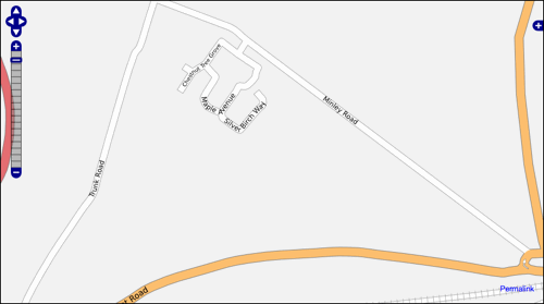
OSM currently has good coverage of the main roads and motorways, but it lacks data for a lot of residential areas. So now, through my running, I am gradually mapping the residential roads of Farnborough.
Before

After

The estate I live on was only built a year or two ago and because of this it doesn’t yet show up correctly on any of the major map providers (which is a pain when getting some delivered!). This means that, thanks to my recent contributions, Open Street Map now has the most accurate map for our particular area.
If you extrapolate this trend a few years in to the future (when all existing roads have been covered) it is easy to conceive a time when OSM will be the most accurate map around. Think about it: residents of a new estate are a lot more motivated to ensure that it appears correctly on the map than the traditional map suppliers, and with OSM this process is easy.
Once this happens, delivery companies will start using it, and possibly even contribute to the project as well (a little investment of time by UPS / Tesco uploading their delivery tracks, could save their drivers a lot of time). So simply put, I think Open Street Map is the future of mapping.
Incidentally, if you would like to sponsor me on my run then you can do so here.